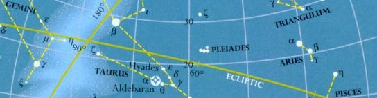
The whole sky and the locations of 77 of the 88 constellations
(including all the ancient figures) are presented in six maps, one
of each of the two polar regions, the other four centered on the celestial equator. The positions of
the missing constellations are described in the text to the
appropriate map. The maps show stars through third magnitude and into fourth
along with their Greek letter names as well as prominent proper names. Exceptional non-stellar
objects are noted. The artificial connections that outline each
figure are not necessarily the same as those presented in the STARS pages. The maps also show the ecliptic, the Milky Way, and its formal center line,
the Galactic Equator (that of the disk of our Galaxy). Each map is presented
for the evening at 8:30 PM (20 hours 30 minutes) for the month at
the top.
| Map 1: The north polar constellations |
| Map 2: The constellations of northern autumn/southern spring | Map 3: The constellations of northern winter/southern summer |
| Map 4: The constellations of northern spring/southern autumn | Map 5: The constellations of northern summer/southern winter |
| Map 6: The south polar constellations |
|